Winter 2020 is characterized by abnormal heat — the temperature maxima of long-term observations are broken. Agriculture specialists so far find it difficult to assess exactly how unusual weather conditions will affect the future harvest. An "electronic agronomist" created by scientists at Samara University will help answer this question. It is a software package that can, by analyzing various factors, predict crop yields and help agricultural producers achieve high rates.
The developed decision support system based on a dynamic yield forecast uses geo-information technologies of accurate farming and Earth remote probing data. Samara scientists have been conducting research in this area for a few years, the software package for accurate farming is constantly developing and receiving new options to increase its abilities. Work is being carried out together with "Samara-Informsputnik" company with the support of the Samara Region Food and Agriculture Ministry. Some operation algorithms of the complex can be found in the article "Information technology for early recognition of crop species from satellite images" in the journal "Computer Optics".
"This software package in agriculture is now actively developing. Thanks to it agronomists and employees of the Ministry of Agriculture, for example, have a complete current picture of agricultural crops. It allows to increase the accuracy and efficiency of resource use, said one of the developers of the system, associate professor of the Samara University Department of Geoinformatics and Information Security Andrew Chernov: — Now we have added an option to the system such as yield forecasting and start developing crop rotation planning. That is, an integrated system, taking into account many factors, will help agricultural producers make informed decisions in their activities. For example, what in what order, at what time and in what amounts to sow, when and what fertilizers to apply in order to get the needed result. "
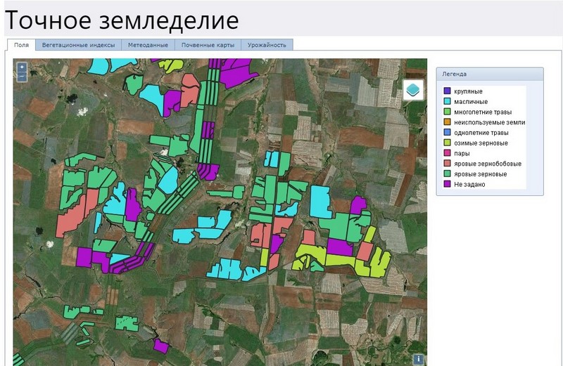
The program complex is engaged in rational planning of the sown areas structure, forecasting yields at various stages — from sowing to harvesting, as well as monitoring and analyzing data on harvested crops — during and after the harvesting campaign. The area of the simultaneously analyzed crops is between 100 and 1 million ha.
To create a yield forecast for a given field, the complex assesses the crops state dynamics according to the images from space, analyzes the temperature, humidity and precipitation, takes into account the types and quality of the crops in this field in previous years, the current state of the soil and even the terrain .
"From the space you can see how crops are developing, what is their NDVI (Normalized Difference Vegetation Index — a vegetation index showing the amount of photosynthetically active biomass). Along with meteorological data, the biological potential of seeds, plant variety, soil quality and many other factors are taken into account ", - said Andrew Chernov.
According to the developers, the Russian agricultural market currently does not have decision support systems based on a dynamic yield forecast. The potential market capacity in this area is from 800 million to 4 billion rubles per year with a total area of analyzed crops of 80 million hectares. It is assumed that farmers will interact with their "electronic agronomist" over the Internet through a web service or a special mobile application. The system can be used by any agricultural producer.
For reference:
At Samara University one of the leading Russian scientific schools has been formed in the field of remote probing data processing (Earth remote probing) and geo-informatics. Scientific work in this direction is concentrated in the Department of Geoinformatics and Information Security, as well as in the specialized research laboratory (NIL-55) and is implemented in partnership with the Institute of Image Processing Systems of the Russian Academy of Sciences and "Samara-Informsputnik" company.
The activities of the research team are aimed at the development and operation of geographic information systems, as well as creation of products and services based on the use of remote probing data in such areas as urban studies and urban planning, development of natural resources and agriculture, cartography and navigation, transport and monitoring of natural disasters. On their basis, mobile applications and geolocation services, environmental monitoring systems, damage assessment for insurance claims, real estate assessment, as well as disaster relief and others are created.
Specialized departments and research centers are equipped with modern systems for receiving and processing space information, information protection complexes, as well as other special equipment.
List of articles:
- Vorobyeva N. S., Sergeev V. V., Chernov A. V. Information technology for early recognition of crop species from satellite images // Computer Optics. — 2016. — T. 40. — No. 6.
- Denisova A. Yu., Kuznetsov A. V., Glumov N. I. Technology for segmentation of agricultural land images using morphological profiles // Information Technologies and Nanotechnologies. - 2018.- P. 576-585.
- Evstiforova A. V., Denisova A. Yu. Analysis of the influence of soil characteristics on the results of regression modeling of winter wheat productivity according to the NDVI vegetation index // Information Technologies and Nanotechnologies. — 2018.- P. 664-673.