 RU
RU  EN
EN  CN
CN  ES
ES 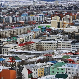
Samara University scholars have developed the prototype of the service for the objective real estate appraisal. It is based on a mathematical algorithm, which allows finding a flat and taking into consideration different factors of urban environment, so that they correspond to the future owners' way of life at most.
"A dweller of a modern megalopolis begins to be aware of the following: one lives not only in one's own flat, but takes one's activity outside, - one of the service developers, employee of Institute of IT, Mathematics and Electronics, Associate professor of Samara University Andrey Chernov says. - Several years ago people just invested in square meters, but now more and more city dwellers are looking for a new flat to change the quality of life. Our service finds all necessary characteristics of accommodation and ambient urban environment for a concrete person quickly and safely by revealing an absolutely defined list of factors".
Apart from the usual criteria influencing the price of square meters (districts, type of site development, floor, room space and its cadastral price), the service offers a more delicate - almost individual setting, which unites more than 20 additional parameters.
The developers qualified the communication factors applying to the transport accessibility of accommodation (distance from the city centre, embankment, parks and squares; transport availability, number of public transport routes and distance to their stops) as them. The local ones are the presence of parking lots, objects of social, cultural and sport infrastructure in the pedestrian availability from the desired flat. As well as internal factors: the condition of the yard, the year of the building construction and the date of the last repairing, presence of passenger and cargo lifts, etc.
In practice, the service represents a mathematical algorithm of collection, storage and handling of different arrays of Big Data, being represented as a geoinformation map.
"Several layers of information, which contain data about object sets, having both fixup and geoinformation bound, are mapped. In a click one gets the complete specification of the flat under consideration, its position in space, i.e. of everything that surrounds it, and calculates its objective price", - Andrey Chernov explains the methodology.
Currently the service allows calculating travel time from the potential accommodation to the work place by personal and public transport, evaluate the convenience of the location of nearby educational, social and sport objects as well as to draw conclusion about the availability and quality of different social service supply.
The scholar provides a vivid example: "Let's suppose, I want to live in the historical centre of Samara in 10 minutes’ walk from the embankment with a good school for my child, park and playground nearby. Herewith, I have a prim and understand that to descend to the embankment along the nearest unrepaired road will be very difficult. When one needs to consider more than 10 or 20 such factors, it is more difficult to solve the problem. Especially if these factors are blurred and contradict one another: e.g. I want to have transport junctions in the pedestrian availability from the house, but, herewith, out of reach of the car noise".
The developers make the point as well that initially their project was being developed with consideration of geoinformation characteristics of Samara, but it can eventually be projected to any Russian city with a million-plus population.
For reference
At Samara University one of the leading Russian scientific schools in the sphere of data processing of Earth remote probing (ERP) and Geoinformatics was formed. Scientific work in this direction is being predominantly conducted at Department of Geoinformatics and Information Security as well as in specialized Research and Development Laboratory (RDL-55) of Samara University and is being realised jointly with Institute of Image Systems Processing RAS and JSC "Samara-Informspunik".
The activity of the research team is directed at the development and exploitation of geoinformation systems as well as making of products and services based on the use of ERP data in such directions as urban planning and development, natural resources development and agriculture, cartography and navigation, transport and monitoring of natural disasters. Mobile applications and geolocation services, ecological monitoring systems, damage assessment for insurance claims, real estate appraisal as well as disaster relief, etc are being created on their basis.
Specialized departments and research and development centres are supplied with the modern systems of receiving and processing of space information, information protective gears as well as other special equipment. Moreover, Samara University has its own hardware-software complex of storing and analytical processing of unstructured data (Big Data).